
Author Archives: admin

Galileo in the Here and Now
No longer consigned to predicting what might one day happen, the folks at the Galileo program can now look at and talk about what is happening right now, starting with initial services. To help us understand what’s going on, we enlisted no less than Matthias Petschke, Galileo Program Director at the European Commission (EC). “Since […]
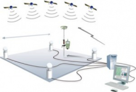
NTRIP/CORS: How it works and what is involved?
NTRIP, CORS and VRS are different things. However, the terms are often used synonymously in our industry. NTRIP (Network Transport of RTCM via Internet Protocol) and CORS (Continuously Operating Reference Station) are forms of RTK differential correction that are done through the use of a cellular modem and base station network. This means that instead […]
การเผยแพร่ข้อมูลภูมิสารสนเทศทางอินเทอร์เน็ต (Internet GIS and Web Map Server)
วันที่ 12 มิถุนายน 2560 จิสด้า ได้จัดฝึกอบรมในหัวข้อ การเผยแพร่ข้อมูลภูมิสารสนเทศทางอินเทอร์เน็ต (Internet GIS and Web Map Server) ณ อาคารสถาบันวิทยาการอวกาศและภูมิสารสนเทศ โดยได้รับเกียรติจาก ผศ.ดร.พิพัธน์ เรืองแสง อาจารย์ประจำภาควิชาวิทยาการคอมพิวเตอร์ คณะวิทยาศาสตร์ มหาวิทยาลัยขอนแก่น เป็นผู้บรรยาย โดยมีนางสาวปราณปริยา วงค์ษา รักษาการผู้อำนวยการสำนักพัฒนาและถ่ายทอดองค์ความรู้ ให้การต้อนรับ การฝึกอบรมดังกล่าวมุ่งเน้นเพื่อให้ผู้เข้ารับการฝึกอบรม เรียนรู้มาตรฐาน OGC (Open Geospatial Consortium) และ ISO (International Standard Organization) และเรียนรู้การให้บริการแผนที่บนอินเทอร์เน็ต การจัดสร้างระบบการให้บริการข้อมูลที่เรียกว่า OGC Web Map Service โดยใช้ซอฟต์แวร์รหัสเปิด (Open Source Software) เพื่อให้ผู้เข้ารับการอบรมได้เข้าใจในหลักการพื้นฐานของระบบ Web Map Service (WMS) ซึ่งเป็นการประยุกต์ใช้เครือข่ายเทคโนโลยีสารสนเทศที่สามารถเชื่อมต่อผู้ใช้กับผู้ให้บริการข้อมูลในระบบ ที่เรียกว่า Geospatial […]
คณะรัฐบาลเมียนมาเยี่ยมชมจิสด้า เพื่อส่งเสริมการพัฒนาเขตเศรษฐกิจทวาย
เมื่อวันอังคารที่ 9 พฤษภาคม 2560 จิสด้าให้การต้อนรับคณะรัฐบาลเมียนมาในฐานะสมาชิก Dawei Special Economic Zone Management Committee ในการเข้าเยี่ยมชมหน่วยงาน พร้อมหารือร่วมเพื่อการส่งเสริมการพัฒนาโครงการพัฒนานิคมอุตสาหกรรมตลอดจนระบบสาธารณูปโภคพื้นฐานของเขตเศรษฐกิจทวายฯ ซึ่งเป็นนความร่วมมือระดับไตรภาคีของรัฐบาล 3 ฝ่าย ได้แก่ รัฐบาลไทย รัฐบาลเมียนมา และรัฐบาลญี่ปุ่น Credit:http://www.gistda.or.th/main/th/node/1852
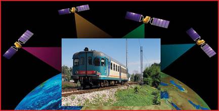
GNSS for ERTMS Train Localization A step-change technology and new business model
GNSS has recently been endorsed as one of the “Game Changer” innovations helping improve the competitivity of the European Railways Train Management System (ERTMS). Backed by more than a decade of studies and technology developments, these authors review the main economical implications behind this unprecedented program together with the benefits for using a public telecom […]
BeiDou’s Applications, Role in Asia Continue to Evolve
Asia is booming, and China’s BeiDou satellite navigation system seems prepped to boom right along with the growing region. Home to more than 60% of the world’s population, Asia is the world’s fastest growing economic region — and an increasingly important GNSS market. China’s BeiDou navigation satellite system (BDS) will expand its cooperation to Thailand […]
ComNav releases Quantum algorithm for its OEM boards
ComNav Technologies has released its new generation Quantum algorithm to international market. The Quantum algorithm can be easily achieved through a firmware upgrade (version 2.5.2 and above), and suits all ComNav OEM boards and OEM-based receivers. An upgrade to ComNav’s Quan algorithm, the Quantum algorithm dramatically improves the stability and reliability of RTK positioning in […]
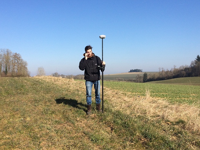
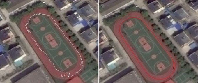
สำรวจได้ 800 จุดต่อวัน – กรณีการใช้งาน T300 GNSS RTK จากประเทศเบลเยี่ยม
Gabriel Rodriguez, Junior Surveyor at Bureau Delvoye in Brussels, Belgium, is surveying more than 800 points a day …
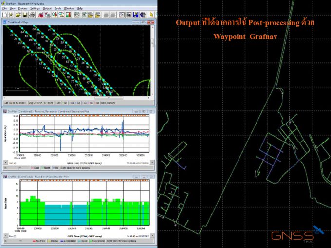
การใช้ software ในการสำรวจแบบ Kinermatic
การนำ Software มาใช้ช่วยในการทำสำรวจรังวัดถือว่าเป็นมิติใหม่ของช่างสำรวจ โดยหลักการพื้นฐานง่ายๆ …
GISTDA ฝึกอบรมการใช้งานระบบภูมิสารสนเทศ GMIS เพื่อการบริหารจัดการโครงการ ของมูลนิธิชัยพัฒนา
วันจันทร์ที่ 27 มิถุนายน 2559 GISTDA ได้ฝึกอบรมการใช้งาน “ระบบภูมิสารสนเทศเพื่อการบริหาร จัดการโครงการของมูลนิธิชัยพัฒนา หรือ GMIS (Geo-informatics Management Information System)” http://gmis.chaipat.or.th ณ สำนักงานมูลนิธิชัยพัฒนา ซอยอรุณอมรินทร์ 36 ถนนอรุณอมรินทร์ แขวงบางยี่ขัน เขตบางพลัด กรุงเทพฯ เพื่ออบรมการใช้งานระบบฯ ให้กับผู้บริหาร เจ้าหน้าที่ ผู้ประสานงาน และผู้รับผิดชอบโครงการอันเนื่องมาจากพระราชดำริ ของมูลนิธิชัยพัฒนา ได้นำไปใช้ในการบริหารจัดการโครงการได้อย่างมีประสิทธิภาพ โดยมี นายลลิต ถนอมสิงห์ ผู้ช่วยเลขาธิการมูลนิธิชัยพัฒนา เป็นประธานกล่าวเปิดการฝึกอบรมในครั้งนี้ ระบบภูมิสารสนเทศเพื่อการบริหารจัดการโครงการของมูลนิธิชัยพัฒนาหรือ GMIS (Geo-informatics Management Information System) เป็น Application ระบบภูมิสารสนเทศออนไลน์ Web Map Service ที่ GISTDA และมูลนิธิชัยพัฒนาได้พัฒนาขึ้นผ่านระบบ Cloud […]